|
|
|
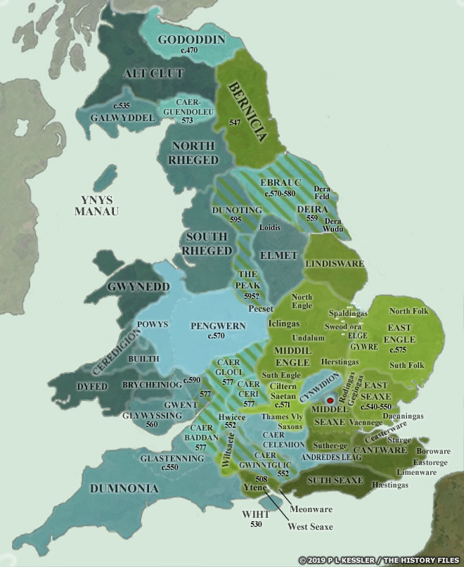
Map of Anglo-Saxon Conquest Britain AD 550-600 |
|
Sub-Roman Britannia underwent rapid change in the course of fifty years between AD 550-600. At the start of this period, the Angle and Saxon kingdoms on the east and south coasts were firmly established. Many of the rapidly-formed Romano-British territories in those areas had been swept away in the late fifth century. A few were managing to hold out, but they were becoming increasingly surrounded and squeezed by encroaching invaders. One reason for the rapid downfall of the Romano-Britons was the disastrous custom of dividing territory between all surviving sons instead of passing it on intact to a single successor (this was especially present in the less civilised west and north). Another was the destructive habit of in-fighting but for which the Anglo-Saxon advance, halted by the apparent British victory of Mons Badonicus, may never have been able to re-start. This map presents the major events of this period. The Romano-British territories are shaded in blue, while the invaders are in green. Angle and Saxon advances are marked by green hatched lines over blue territory, accompanied by the year in which the territory fell. All borders are conjectural, but rough territorial boundaries are known. A clickable version of this map is available for desktop displays. To select a territory for further information, click anywhere within its borders.
(Click or tap here to skip notes and go to map navigation)
Notes Andredes Leag Later known as Andredsley, Andredes leag or weald was a large stretch of highly dense ancient woodland which started in modern Kent in the region of the Limenware and extended across most of the northern border of Sussex. The wood was, from east to west, approximately 193km, perhaps longer, and 48km deep. In 477, Ælle and his Suth Seaxe landed on the southern coast and drove the British defenders into the woods which they associated with the nearby British fort of Andredes ceaster (Brythonic 'Anderita'). This fort was defended by men who were possibly part of the proposed British state of Rhegin. In Ælle's time many of the Roman roads through the woods were still in good condition, and these provided access to the Saxons of the Thames Valley and the Suther-ge. But they were allowed to deteriorate, and in time Sussex became isolated. Boroware This group of Cantware settled in or around the Roman territorium of Durovernum Cantiacum (Canterbury). The former cantonal capital became Cantwara burh, or 'fort of the men of Kent'. Ceasterware At the point at which Watling Street crossed the River Medway, Roman Durobrivae retained only the garbled second syllable of its name in Hrofesceaster (Rochester in Kent). The original name probably meant 'walled town with bridges' and its form did not change much for centuries. The Ceasterware were simply the 'people of the fort'. Daenningas The Daenningas settled between modern Colchester and the coast at Bradwell, and became part of the East Seaxe kingdom. The modern area of Dengie still bears their name, from the Saxon Deningei - the region of the Daenningas. The first written reference to Deningei can be traced to an eighth century charter. Dornsaete The West Seaxe invaded the eastern half of Dumnonia in 614. It seems likely that it was around this period that independent Saxon groups were able to make inroads into the British kingdom's territory to found new settlements where Dumnonian defences and the inhospitable coastline had previously prevented coastal landings. They named themselves from the local Romano-British name of Caer Durnac or Roman Durnovaria (modern Dorchester, from the Celtic tribe of the Durotriges). The Dornsatae were independent until circa 650-670. Eastorege Modern Eastry near Sandwich in Kent was known as the Eastore-ge, the 'Eastern region' of the Cantware kingdom. Its name was first written down in a charter of 811 as regione Eastorege. Elge The island of Ely in Cambridgeshire was called Elig by the Angles. The original term was Elge, 'an eel' (according to Bede). Alternatively, even though very few British names survived in the Midlands or east, the name may descend from the British 'helyg', 'a willow', a tree which grew plentifully thanks to the marshy nature of the local soil. By the late fifth century Ely had become an island which was surrounded by undrained marsh. The East Engle reached the area by AD 500, using the river routes to advance swiftly. For the next century the Cambridgeshire area was disputed territory between the East Engle and the Middil Engle, until the latter were pushed back by the dark age equivalent of superior firepower. Gegingas Quickly subsumed within the East Seaxe kingdom, a large area to the south-west of Chelmsford was known as Gigingas or Gegingas after the people who settled there. This included the syllable 'ing', meaning 'possession', and is seen in the names of Ingatestone, Fryerning, Margaretting, Mountnessing, and Ingrave. It appears that the Normans later divided up the territory, and Ingatestone and Fryerning were known collectively as Ging-at-the-stone. The Gegingas were positioned immediately to the east of the Rodingas on the other side of the Roman road which divided them. Gywre Neglect of the Roman engineering works and land subsidence after AD 450 in the area of Cambridge and Ely reduced drained fenland to marsh, isolating Ely and other islands. Within these areas lived a dark-haired, independent people called the Gywre, who were possibly Celtic in origin. During the seventh century, the East Engle's King Sigeberht appointed Felix as the first bishop of the newly established bishopric of Ely. Sigeberht's successor was Annah. His daughter, Ethelreda, was influenced by Felix into pledging her virginity to Christ, but that didn't prevent her from making two political marriages. The first of these, most notably, was to Tonbert, chieftain of the Southern Gyrwe (the Northern Gyrwe were apparently located closer to The Wash), which brought her Ely as her inheritance, either as a dowry from her husband or by right of her birth as a Wuffinga of the royal house. The second marriage was to Northumbrian King Ecgfrith (670-685). In 672 Ethelreda fled from him when he demanded consummation of the marriage. She sought sanctuary on the Isle of Ely, establishing a double abbey of monks and nuns under her as abbess. Clearly, the mysterious Gywre not only survived for at least two and a half centuries after the collapse of British authority in the east, but their leader was in a position to claim the hand of the daughter of the East Anglian king. Unfortunately, there seems to be no other mention of this tribe so presumably they eventually blended into local Angle society and that of the later Danish settlers. Notably, though, there was a tradition amongst certain folk of the Cambridgeshire area in which they regarded themselves as kin to the Welsh. This persisted into the early twentieth century at least. Hæstingas The Hæstingas were a substantial band of people which settled in the area around modern Hastings (Hastingacaestre), the name revealing the existence of a castle or fort at that time. They were eventually subsumed by the Suth Seaxe. The settlement of Hastings itself was moved eastwards by the end of the Anglo-Saxon period, which is where it stayed barring a small relocation into what is now the Old Town Valley in 1069. Herstingas The tribe of the Herstingas formed part of the Middil Angle peoples, being situated to the north-west of Cambridge. Hwicce The Hwicce emerged from obscurity, probably from within territory which was initially controlled by the West Seaxe, to form their own kingdom from 577. Initially they may have been under the dominance of the West Seaxe, but after their defeat of 584 the West Seaxe apparently drew back from the border area. The Hwicce may not have been very numerous, and there are indications that they became integrated into the existing British culture in the area, simply becoming its new ruling nobility. The Magonset and Wrocenset (shown on the Anglo-Saxon sequential maps for AD 650) were probably part of their grouping, although there is also the possibility that they had links to Mercia. Once British Pengwern had fallen in 656, they moved in to fill the gap in the west of the territory. Limenware The Limenware were a group of Cantware who settled near the Roman fort of Lemanis (now Lympne). They adopted the name to identify themselves at the territorial centre of what became the lithe (the early administrative centres of the kings of Kent) of the Limenware in the form of Lyminge, or Limin-ge, the region of the Limenware. Other areas in Kent were organised in the same way, suggesting that the Cantware may have been perpetuating the governmental pattern of this part of Kent from late Roman times. It has also been suggested that these early lithes began as semi-independent settlements or petty kingdoms in their own right and were only slowly brought under the central control of the kingdom. Loidis The name Loidis was applied to the district and not to a single place or settlement. This is confirmed by two names, Ledsham and Ledston, which both contain the same element. These two villages are about fifteen kilometres from the city of Leeds. The name then became 'Leodis', then 'Ledes', when it was mentioned in Domesday Book in 1086, and then Leeds. Leeds may have been the centre of a Roman settlement, although there is no definite evidence for this. Some sources suggest that British Loidis was a kingdom in its own right, but it seems much more likely that it was a subdivision of Elmet. It was noted as 'Elmete (Loidis regio)', which also suggests that the kingdom of Elmet was to be found in the Leeds region. Originally, Loidis may have been the name of a tribe and could mean 'people of the flowing river' - an early reference to the River Aire on which Leeds is situated. An eleventh century manuscript claimed that in the tenth century, Loidis lay on the boundary between the Viking kingdom of Jorvik (York) and the British kingdom of Strathclyde (which included Lancashire, Cumbria, and south-western Scotland). A saint called Cadroe is said to have visited both Strathclyde and Jorvik in the tenth century, receiving the hospitality of the kings of these two states. The two kings are said to have met at Loidis during Cadroe's passage from one kingdom to the other. Meonware The Meonware were a colony of Jutes who came round Southampton Water and up the Solent to settle there circa 450. It is not clear precisely when they were conquered by the West Seaxe, but they retained their identity for at least two centuries. North Engle The North Engle were part of the Middil Engle peoples. They were located in modern Nottinghamshire (Nottingham is a preservation of the North Engle name), and circa 600 they were conquered by the Iclingas. Pecset Prior to their movement into the Peak District and the adoption of this name to reflect their new settlement circa 590, this group of Saxons was part of the Middil Engle peoples, and was probably located close to modern Nottinghamshire. No doubt they ventured over the border into the surrounding British territories from time to time. Rodingas Amongst the East Seaxe peoples could be found the Rodingas, based on the modern group of Roding villages in Essex, and positioned immediately west of the Gegingas. Their settlements covered an area of about thirty kilometres across in the heart of Essex, north-west of modern Chelmsford, and were therefore more likely to have derived from a Saxon than an Anglian background on continental Europe. J N L Myres, The English Settlements, points out that the Essex Rodingas may have taken their name from the Rodingas who appear as a continental tribe in Widsith, descended perhaps ultimately from the Reudigni of Tacitus. Somersaete The Saxon conquest and occupation of Somerset was a long and slow process which began with the battle of Dyrham in 577, when the West Seaxe (West Saxons) defeated the Britons of Caer Baddan et al. This victory brought the West Saxons to Bath, and perhaps further groups of Saxons across the River Avon into the northern parts of Somerset where, seemingly independent, they became the Somersaete ('Summer settlers', because the marshes and flatlands here were largely dry and habitable during that season). After nearly a century, the West Seaxe advanced after victories at Bradford-on-Avon in 652 and in 658 at Penselwood, the densely forested area on the eastern boundary of Somerset. These victories opened the way into Somerset through the forests and marshes to the River Parrett. In 682 the West Seaxe cleared the western coastal area of Somerset as far as the Devon border. The final stage in securing the conquest of Somerset was carried out by King Ine, and was completed with the victory over Geraint of Dumnonia in 710. Spaldingas The first written record concerning Spalding was a charter issued in AD 716 by King Aethelbald of Mercia to the monks of Crowland Abbey. Another charter written in 868 referred to Spaldelying. The Spaldingas settled in the fens and marshes of East Anglia. The core of their territory was located at the point at which a road ran over the low country to the Wash. 'Yng' is a Celtic word for fen or low meadowland; today, the fens are still known as 'ungs'. The district name is related either to Old English spâld 'spittle' or to an OE *spald which is cognate with Old High German spalt 'a ditch, a trench', either perhaps referring to a Roman drainage canal, of which the area had many. In Domesday Book, prepared for William 'the Conqueror' in 1086-1087, Spalding is spelled 'Spallinge'. In Latin, 'spall' or 'spald' means 'the shoulder'. The town of Spalding of Saxon derivation means literally: 'the tribe who live at the shoulder' (marsh or swamp dwellers). Suth Engle Part of the Middil Engle peoples, the South Engle were situated in modern Oxfordshire and Buckinghamshire, where they had greatly compressed the northern border of the British kingdom of Cynwidion. They were conquered by the Iclingas around AD 600. Undalum Forming part of the Middil Engle (Middle Angle) peoples, the tribe of the Undalum or Undele were situated between Kettering and Great Casterton. Their name survives in the town of Oundle in Northamptonshire. Wiltsaete The Wiltsaete (Wiltshire Saxons) were gradually conquered by the West Seaxe between circa 495 and 560. Their settlements lay on the western border of the British territories of Caer Celemion and Caer Gwinntguic. Not shown on this map because they didn't begin to advance into eastern Dumnonia until the seventh century are the Somersaete and the Dornsaete. The Hwicce also apparently emerged from Wiltshire after 577. Ytene Ytene, where the letter 'Y' is pronounced as a 'U' is the same as 'Jutes'. The Jutes living in Hampshire were part of the original kingdom of the West Seaxe which was taken over by Cerdic in 495. It is generally accepted (even if it cannot be categorically proven) that the Jutes can be identified with the continental Eotens, which locates their original home in Jutland, close to the Danes who were migrating south from Scandinavia in the fourth and fifth centuries. In Old Norse, Jotar is the name given to the Danes of Jutland, and they generally adopted local names for themselves, so the name likely existed when they arrived. Although the bulk of the Jutes who arrived in Britain may have been governed by Angles, some Jutes may have mingled with the Saxons in their Continental expeditions and settlements because the Frankish king of Austrasia, Theudibert I (534-538), when writing to Justinian, mentions that he had Jutes (Eucii) in his kingdom.
Map navigation: |
|
Original text and map copyright © P L Kessler, Edward Dawson, and the History Files. An original feature for the History Files. Go back or return home. |