|
|
|
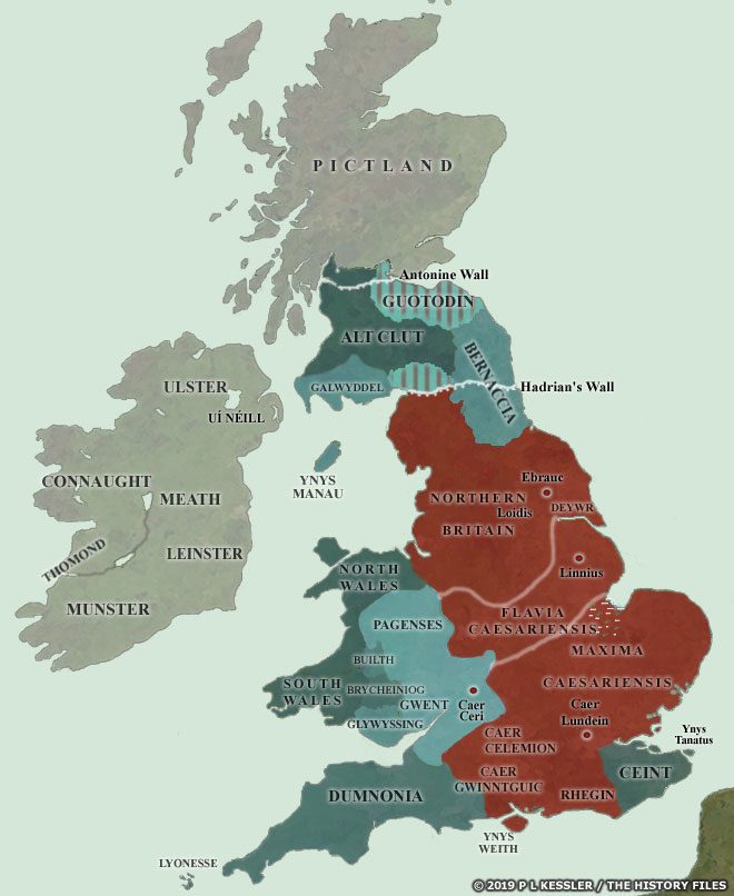
Map of Early Independent Britain AD 400-425 |
|
Faced with an economic downturn in the second half of the fourth century and various barbarian raids and more serious incursions, Roman Britain exhibited a marked decline in fortunes. Various internal revolts meant that military units were greatly depleted, with two strong forces being taken onto the Continent never, it seems, to return in any great number. Various client states were set up (or officially acknowledged) in the west and north. Renewed war flared up against the Picts of the far north, apparently lasting 'for many years'. Further Scotti (Irish) raids took place on the south coast of Britain in 404/405, just as a major force of imperial troops was being withdrawn. The British provinces were relatively isolated and lacking in support from Rome in their fight against barbarian incursions. In 409 the Britons expelled all Roman officials, breaking ties which were never renewed. Following the break with Rome there came a period in which central administration apparently began to break down. And then Vortigern seemingly came to the fore, already powerful in the semi-independent Pagenses/Paganes territories of the west... All borders are conjectural, but rough territorial boundaries are known. A clickable version of this map is available for desktop displays. To select a territory for further information (usually in the accompanying feature if an entry is available), click anywhere within its borders.
Map navigation: |
|
Original text and map copyright © P L Kessler and the History Files. An original feature for the History Files. Go back or return home. |