|
|
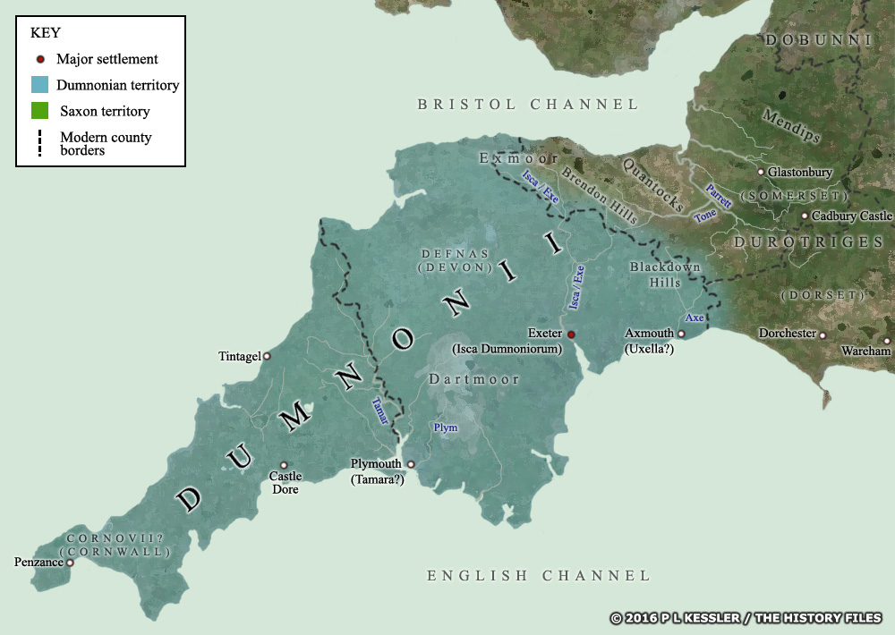 |
Dumnonia in Maps - Map 1 c.10 BC |
|
The Dumnonii were not encountered by Julius Caesar in 55-54 BC, so the first specific mention of them in history is in AD 43-44, during the Roman conquest of the south and east of Britain. By this time the tribe occupied all of modern Cornwall and Devon, with a potential tribal centre at Isca - modern Exeter. (Note that borders are largely conjectural, based on available evidence.) Map 1 of 10. Go back, return home, or go to Kingdoms of the British Isles: Dumnonia. |
 |
|
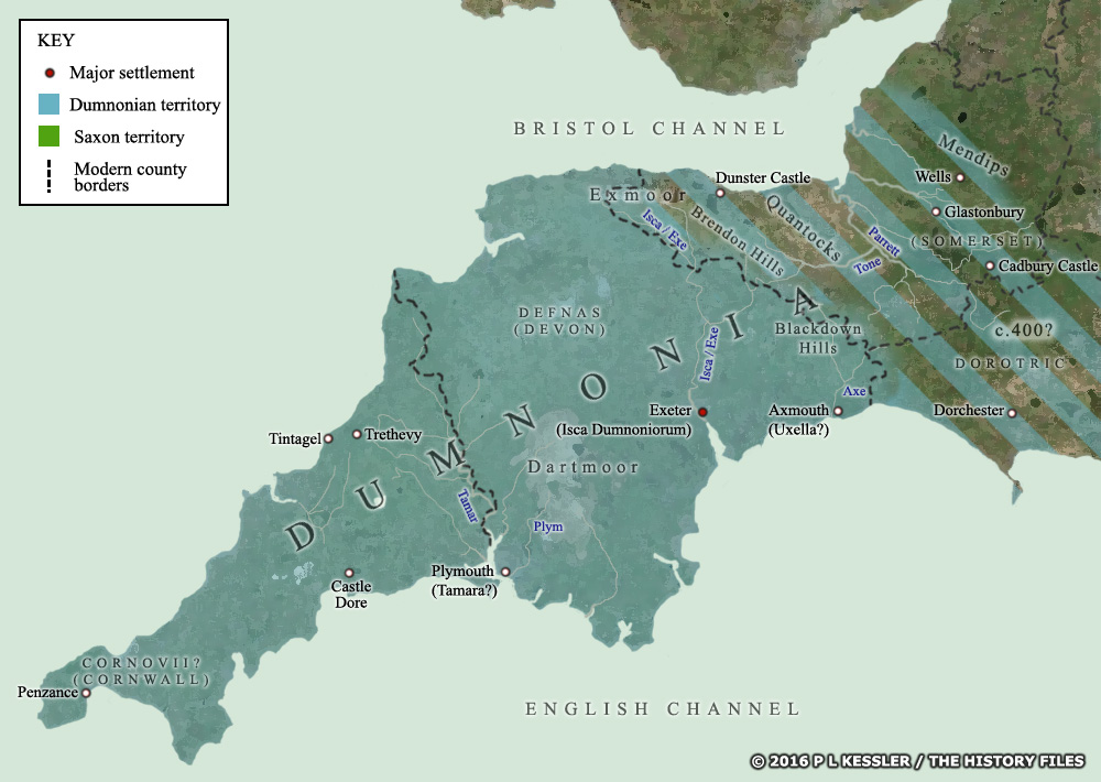
Dumnonia in Maps - Map 2 c.AD 400 |
|
By this time, Dumnonia had probably extended the territory under its control to include the former lands of the Durotriges in neighbouring Dorset. No Durotrigan state re-emerged there when central control was apparently waning, while the Dumnonians were clearly a powerful force. Precisely when they felt they could expand the territory under their control, and how far they extended it is entirely unknown. (Note that borders are largely conjectural, based on available evidence.) Map 2 of 10. Go back, return home, or go to Kingdoms of the British Isles: Dumnonia. |
 |
|
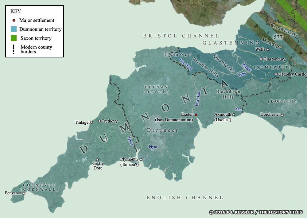
Dumnonia in Maps - Map 3 AD 577 |
|
The advance of Dumnonia's borders (presumed to be in the late third century) perhaps gave it the greatest amount of territory in its history - which it held for about two centuries. Around AD 550, Glastenning was formed across much of Somerset, possibly independent of Dumnonian control. But worse was to come in 577, when the West Seaxe removed the entire area between Gloucester and Bath of British resistance. However, the West Wansdyke appears to have remained in British hands, which would have meant Dumnonian or Glastenning hands. (Saxon territory and conquests are shown in green. Note that borders are largely conjectural, based on available evidence.) Map 3 of 10. Go back, return home, or go to Kingdoms of the British Isles: Dumnonia. |
 |
|
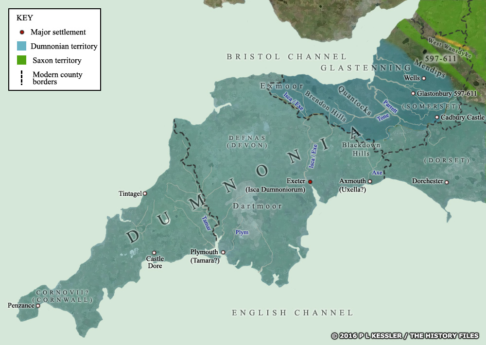
Dumnonia in Maps - Map 4 AD 597-611 |
|
Between 597-611 the West Seaxe managed to clear the British out of the Wansdyke region, and the defenders probably fell back to their pre-577 borders. Even so, they appear not to have remained there, or at least sent forward raiding parties. It is around this time (in the early years of the seventh century) that the Britons of Glastenning founded Glastonbury Abbey. The fact that they were able to do this meant that the West Seaxe conquest of the West Wansdyke had not proceeded particularly far south, and Glastonbury was still in British hands. (Note that borders are largely conjectural, based on available evidence.) Map 4 of 10. Go back, return home, or go to Kingdoms of the British Isles: Dumnonia. |
 |
|
Dumnonia in Maps - Map 5 AD 652 |
|
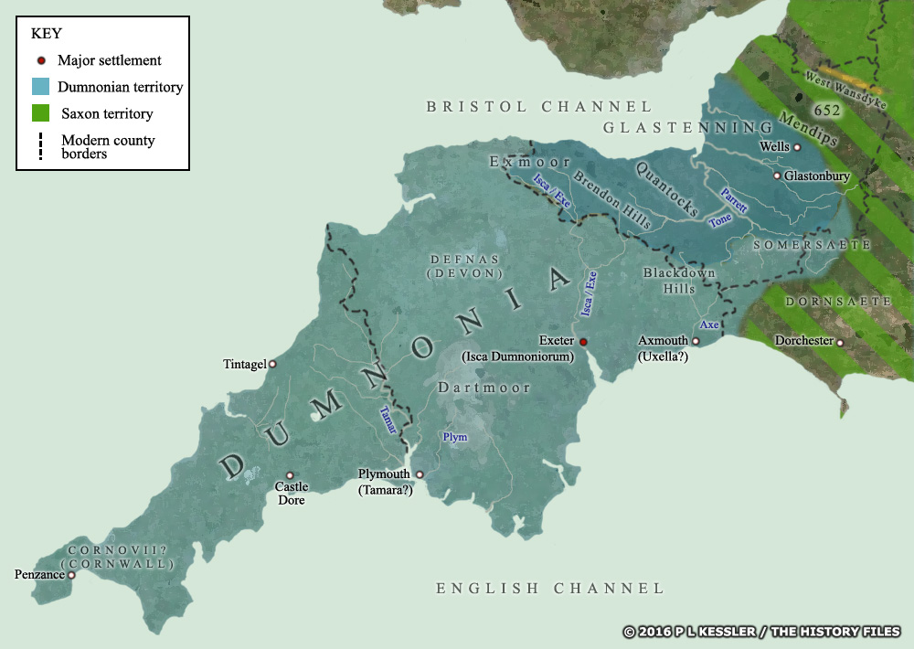
The West Saexe made a breakthrough against the Dumnonian defensive lines at the battle of Bradford-upon-Avon in AD 652. This meant making use of the gap in the Wansdyke caused by the passage of the River Avon, but why the Dumnonians were this far forward is unknown. Either they could have retaken the line of the River Avon and were defending it, or they had advanced there to give battle in the hope of regaining the river. Their defeat meant that the Saxon victory of 652 was essentially a repeat of the supposed gains of 597-611, but with the apparent addition of much of modern Dorset. (Note that borders are largely conjectural, based on available evidence.) Map 5 of 10. Go back, return home, or go to Kingdoms of the British Isles: Dumnonia. |
 |
|
Dumnonia in Maps - Map 6 AD 658 |
|
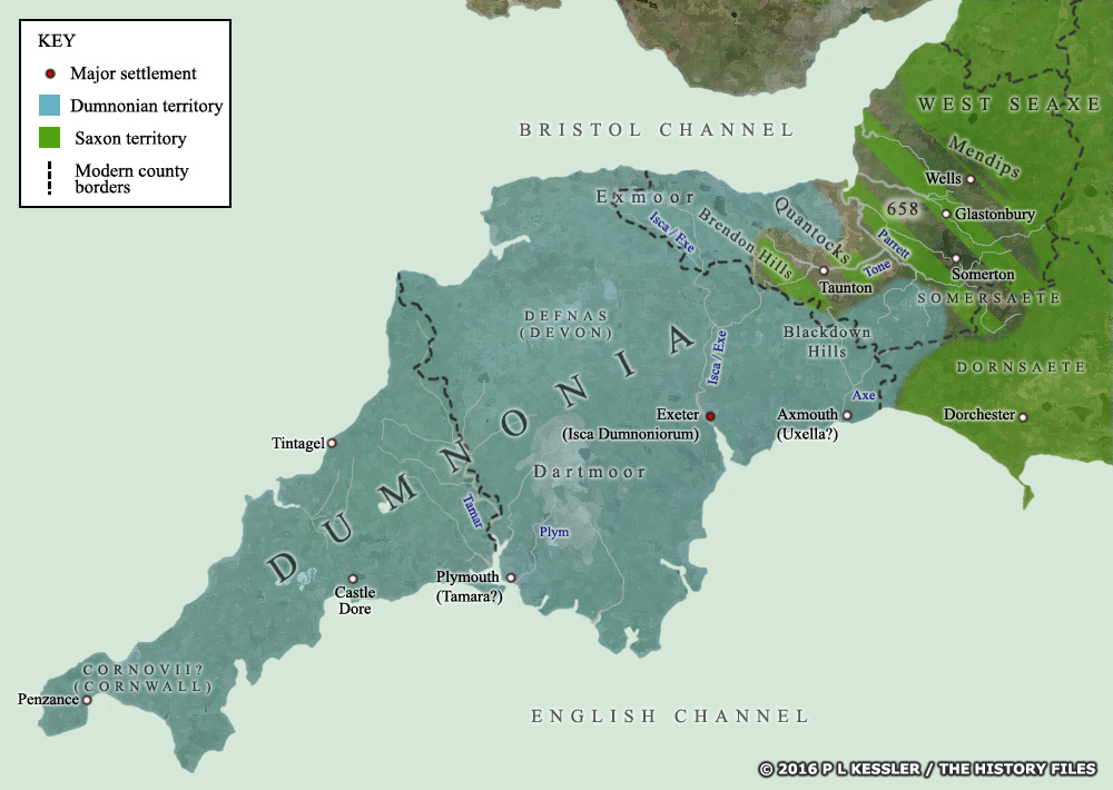
The West Seaxe were victorious at the Battle of Peonna (Penselwood - the densely forested area on the eastern boundary of Somerset), and the Dumnonian forces were put to flight to the River Parrett. The eastern half of Dumnonia was permanently captured by the Saxons as they advanced through the Polden Hills to the new border of the River Parrett. They may have gone even farther than this, to the hills which separate Somerset from Devon, as place names suggest settlement well before the end of this century. Glastenning probably fell at the same time. The Somersaete also now came under West Seaxe control (if they didn't already after 652), as did Glastonbury Abbey, which was allowed to retain its British abbot. (Note that borders are largely conjectural, based on available evidence.) Map 6 of 10. Go back, return home, or go to Kingdoms of the British Isles: Dumnonia. |
 |
|
Dumnonia in Maps - Map 7 AD 661-685 |
|
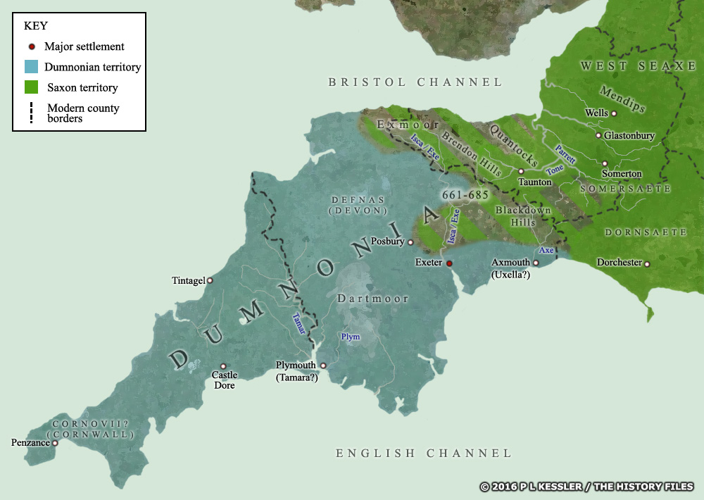
An Easter battle was fought at Posentesbyrig in AD 661 - which could be the Iron Age hill fort at Posbury. Assuming a West Seaxe victory, this would have given them control of the fertile lands of the Exe and Creedy valleys, north of Exeter itself. Between AD 681-685 the West Seaxe conquered the remainder of Somerset as Centwine cleared the western coastal area as far as the Devon border. The territory of the Defnas was also apparently taken by an army pressing along the English Channel coast from Dorset to Exeter. While this serves to confirm that Dorset had fallen to the Saxons, it does not confirm a complete conquest of Devon. (Note that borders are largely conjectural, based on available evidence.) Map 7 of 10. Go back, return home, or go to Kingdoms of the British Isles: Dumnonia. |
 |
|
Dumnonia in Maps - Map 8 AD 710 |
|
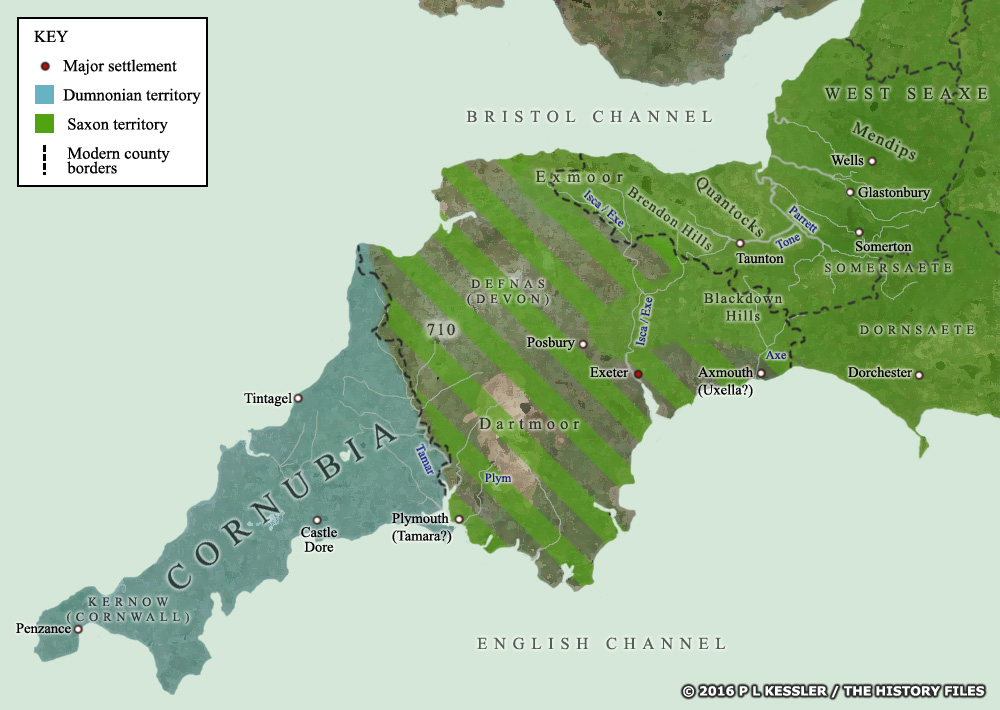
In AD 710 the West Seaxe made their big breakthrough. King Ine defeated and killed Gerren of Dumnonia, inflicting another, very heavy defeat on his British neighbours to the west. This victory seemingly brought West Seaxe domination to the line of the River Tamar, limiting the Britons to Cornwall. The Anglo Saxon Chronicle labelled Gerren 'the Welsh king' and some published compilations fail to list the battle's outcome, but either way Devon was lost and the Dumnonians were bottled up on the western side of the Tamar... or were they? (Note that borders are largely conjectural, based on available evidence.) Map 8 of 10. Go back, return home, or go to Kingdoms of the British Isles: Dumnonia. |
 |
|
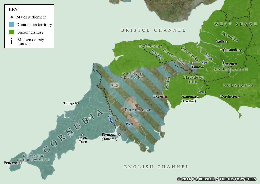
Dumnonia in Maps - Map 9 AD 722 |
|
Three notable 'Cornish' victories are dated tentatively to this year. The battles took place at Hehil, Garth Maelog, and Pencon (Pencoed). Subject to much speculation, all three battles are likely to be in what is now Devon, close to Dumnonia's eastern border. These victories were hugely important, as they apparently won the Dumnonians a century of peace. The victories may even have penetrated far into Devon - a West Saxon attack of AD 814 seemed to aim at the recovery of these regions. Also in AD 722, Queen Æthelburg of the West Saxons destroyed the fort at Taunton. Could this have been to prevent it being captured by attacking Britons?. (Note that borders are largely conjectural, based on available evidence.) Map 9 of 10. Go back, return home, or go to Kingdoms of the British Isles: Dumnonia. |
 |
|
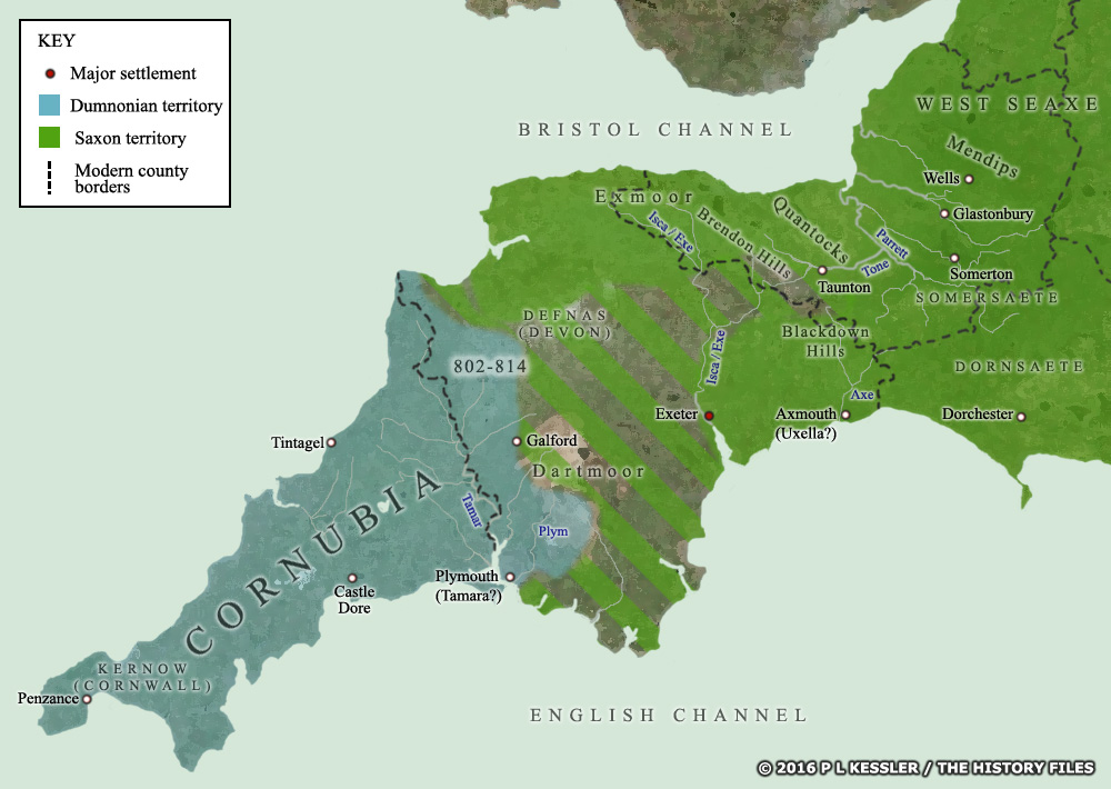
Dumnonia in Maps - Map 10 AD 802-825 |
|
The victory of AD 722 seems to have remained largely unchallenged for almost a century. It must have delivered the Saxons a devastating blow to knock them out of the battle for that long. But the ninth century witnessed a new breed of West Saxon kings, hardened by fighting highly mobile and aggressive Vikings. In AD 814 King Ecgberht of Wessex invaded and subdued parts of Dumnonian Devon. An attack of AD 802 seems to have been trumped up into a great victory but it still took another attack to regain most of Devon. The Battle of Galford in AD 825 - a potential border post after 814 - witnessed a fight between both sides, but possibly no border changes. In fact, the border may have remained as shown here until AD 875 or later, by which time the surviving free Dumnonians were now permanently kept behind the Tamar, never again to mount a recovery attempt of Devon. (Note that borders are largely conjectural, based on available evidence.) Map 10 of 10. Go back, return home, or go to Kingdoms of the British Isles: Dumnonia.
Map navigation: |
|
Original text and maps copyright © P L Kessler and the History Files. An original feature for the History Files. |