|
|


|
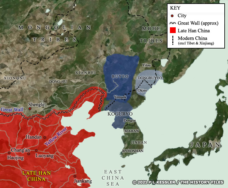
Map of East Asia c.100-37 BC |
|
The first century BC witnessed the final collapse and disintegration of the semi-legendary state of Wiman Choson. A large successor state was created out of that by one of its generals, and it was this which led the Korean peninsula into more reliably-recorded history. The state of Buyeo was located largely to the north of the modern North Korea (above the dashed line which marks that border on the map), in what today is Manchuria in the far north-eastern corner of China. Much of this region was inhabited by proto-Korean tribes until later waves of nomadic barbarians forced them down into the Korean peninsula for safety (mainly in the first five centuries AD). Buyeo quickly spawned an offshoot in the form of Dongbuyeo (in 86 BC). That vassal state was extinguished within a century or so (AD 22), leaving a minor (possibly tribal) state known as Galsa Buyeo, presumably within its original, roughly-defined borders. The state of Koguryo was also a splinter state from Buyeo. Its founding prince had been expelled from Buyeo's royal court, although that same court appointed Yemaek tribal lands to him, near the modern Korean border. He formed those Yemaek tribes into a recognised state in 37 BC, and Koguryo would go on to dominate all of Korea's tribal territories in modern North Korea and Manchuria within a few short centuries. A clickable version of this map is available for desktop displays. To select a kingdom, state, or tribe for further information, click on its name.
Map navigation: |
|
Original text and map copyright © P L Kessler and the History Files. An original feature for the History Files. Go back or return home. |