|
|
|
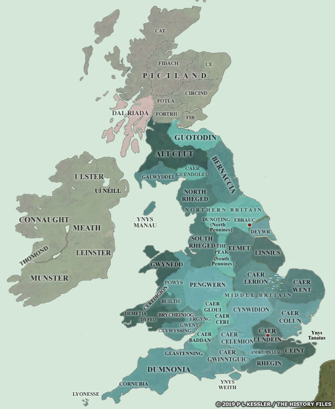
Map of the Island of Britain AD 450-600 |
|
This map of Britain concentrates on British territories and kingdoms which were established during the fourth and fifth centuries, as the Saxons and Angles began their settlement of the east coast. It provides an overview of all the territories known or estimated to have existed under Romano-British control, although not all of them existed at the same time, or in the same form as shown here. Many territories in the south-east appear to have been slow to assume any independent status and were very short-lived, while others in the west had shifting borders and a sketchy history which suggests a gradual transition from Roman-style administration to Celtic kingdom. At this stage modern England did not exist (the name derives from Engle-land, in use from no earlier than the mid-sixth century to describe the 'land of the Angles'); neither did Wales (a Saxon name which is generally taken to mean 'foreigner' or 'stranger' but which is more probably a mangled form of the original name for Celts). Scotland was either known as Caledonia (the Roman version of a tribal name), or Pictland after the name (seemingly coined by the Romans) for the majority of its Celtic population. The Irish Scotti tribe, the Dal Riada, were only just beginning to migrate onto the western coast of Pictland, around Argyll. Most of the kingdoms shown have some historical basis but some, especially those in the south and east of what later became England, are less definite. Their borders remain mostly or entirely conjectural, and the existence of some of them is based on fragmentary evidence. The historical validity of each kingdom (where there is doubt) is mentioned in its king list text. (This map was reproduced with permission in the novel, An Elmet Inquest, by John H Egbers, 2011. See the Post-Roman Britain section of the Sources page for details.) A clickable version of this map is available for desktop displays. To select a territory for further information, click anywhere within its borders.
Map navigation: |
|
Original text and map copyright © P L Kessler and the History Files. An original feature for the History Files. Go back or return home. |