|
|


|
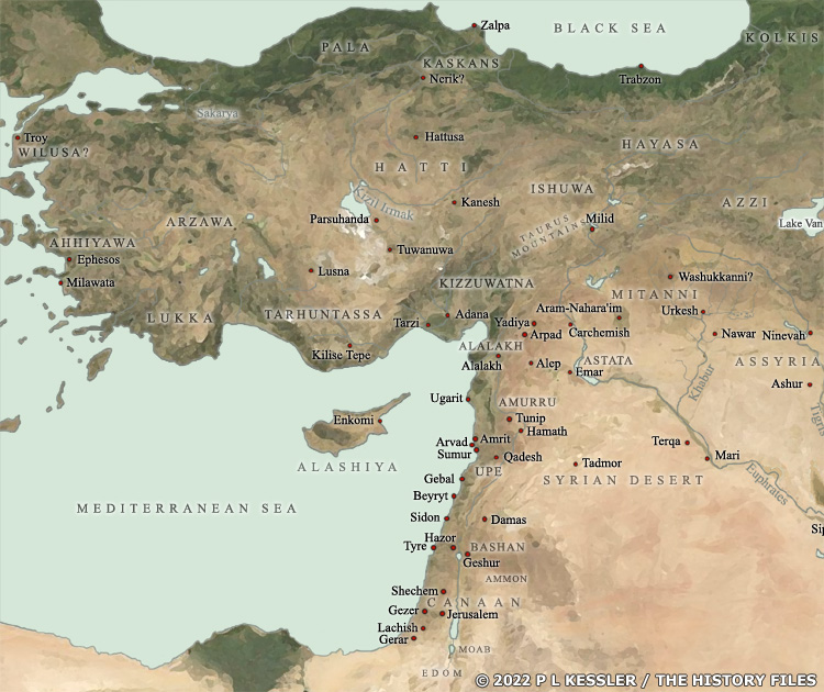
Map of Anatolia and Environs 1550 BC |
|
Following their conquest of the Hatti, the Hittites had been dominant in central Anatolia between 1650-1595 BC, before internal instability ended that dominance. A short dark age followed the Hittite collapse and the creation of power vacuums in Babylonia and Syria (caused by the Hittites) during the sixteenth century BC. During that time new states rose to prominence, including the Luwian states of Arzawa and Kizzuwatna in Anatolia, Mitanni in northern Mesopotamia, and possibly Ahhiyawa in western Anatolia. Other minor states which were probably confederacies sprang up in the north-western corner of Anatolia (Wilusa), in eastern Anatolia and northern Mesopotamia (Hayasa-Azzi and Ishuwa), and in the Caucasus (Kolkis). The Syria-Palestine coastal area saw the emergence or growth of a number of new city states, mostly under the domination of Egypt at a time in which trade crossed a multitude of borders and languages. This was the 'international system' in which the great empires communicated frequently with each other, and played power politics in Syria, using the city states there a buffer region. By about 1430 BC in Anatolia, Hittite power began to be restored. They expanded into Syria and by the 1330s BC had conquered or subjugated most of Anatolia and northern Mesopotamia. However, within a century or so their regional dominance was coming to an end. Somewhere around 1200 BC, perhaps up to a decade before it, regional drought and famine began to cause massive upheaval as many of the states shown on the map were destroyed or disappeared entirely, and the old order was swept away. Main sources A clickable version of this map is available for desktop displays. To select a state for further information, click on its name.
Map navigation: |
|
Original text and map copyright © P L Kessler
and the History Files. An original feature for the History Files. |